Raymarine Plotter Upgrade
12/04/14 14:04
Is it time to upgrade your plotter? Sounds too expensive?
How about doing an upgrade that is absolutely free and just takes a few minute? Many of the new Multifunction displays (MFDs) allow you to upgrade them with new versions and new functionality as it becomes available. Our Raymarine MFDs e95 + e125 9 and 12 inch units respectively have just had an upgrade and I am very impressed. There is a big jump in functionality, especially if you sail in US waters and we are heading there in the next few weeks. Apparently the NOAA charts are now available to run on the plotters, and even better they are free - both as raster and vector versions.
Upgrading
The process is quite simple these days. No visiting a dealer, rewiring, or anything. You just need a reasonable internet connection as you will be downloading the files. In this case the main file is 700MB or so. However I also will want to download the new charts for the US waters. These are also free but are larger at 2GB for the whole shebang! So far I have just done the software upgrade - not the charts. Perhaps I’ll try it out at dinner tonight at Saba Rock :-) with their excellent free wifi?
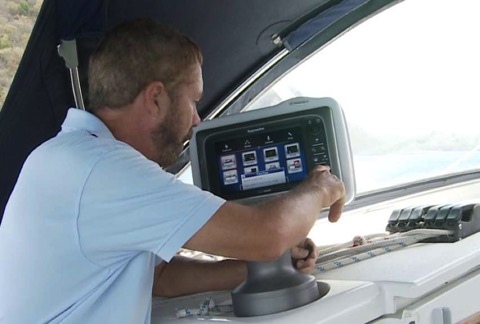
Once downloaded, you can follow along with a simple procedure (here) . Basically put the files on a blank microSD chip, backup your user data from the MFD, and then boot with the microSD in the slot. The boot / upgrade process went quickly and had no hiccups. Clear the cache, then reinstall my user data (waypoints and tracks) and "Bob's your uncle" the new "Lighthouse" software is up and running. Repeat for additional plotters.
I'll be testing the new software the next few days before we head off on our passage to the Bahamas in the next couple of days.
And as soon as I get a decent internet connection I will download all those free US charts that now work on my Ray MFDs. Cool!
Whichever system you use, it might be worth checking if there is an upgrade available. The modern systems offer these upgrades but if you don't check you might be missing out on a sweet deal!
Have you updated your plotter software recently?
How about doing an upgrade that is absolutely free and just takes a few minute? Many of the new Multifunction displays (MFDs) allow you to upgrade them with new versions and new functionality as it becomes available. Our Raymarine MFDs e95 + e125 9 and 12 inch units respectively have just had an upgrade and I am very impressed. There is a big jump in functionality, especially if you sail in US waters and we are heading there in the next few weeks. Apparently the NOAA charts are now available to run on the plotters, and even better they are free - both as raster and vector versions.
Upgrading
The process is quite simple these days. No visiting a dealer, rewiring, or anything. You just need a reasonable internet connection as you will be downloading the files. In this case the main file is 700MB or so. However I also will want to download the new charts for the US waters. These are also free but are larger at 2GB for the whole shebang! So far I have just done the software upgrade - not the charts. Perhaps I’ll try it out at dinner tonight at Saba Rock :-) with their excellent free wifi?
Once downloaded, you can follow along with a simple procedure (here) . Basically put the files on a blank microSD chip, backup your user data from the MFD, and then boot with the microSD in the slot. The boot / upgrade process went quickly and had no hiccups. Clear the cache, then reinstall my user data (waypoints and tracks) and "Bob's your uncle" the new "Lighthouse" software is up and running. Repeat for additional plotters.
I'll be testing the new software the next few days before we head off on our passage to the Bahamas in the next couple of days.
And as soon as I get a decent internet connection I will download all those free US charts that now work on my Ray MFDs. Cool!
Whichever system you use, it might be worth checking if there is an upgrade available. The modern systems offer these upgrades but if you don't check you might be missing out on a sweet deal!
Have you updated your plotter software recently?
Comments
The Miracle of Radar
28/02/14 10:52
On passage from St Martin to the British Virgin Islands…
We are up in the dark and raising anchor before dawn. It is a Caribbean morning with a salt tang blowing a flukey breeze off the beach and St Martin's distinctive lagoon behind. The high bulk of the island to the east hides the orange glow of sunrise and shades us from the trade-winds. Five large cruise ships are approaching from the southwest, steaming past us toward Philipsburg. It will be busy in St Martin today. But I am looking forward to a day at sea after our time in this bustling island.
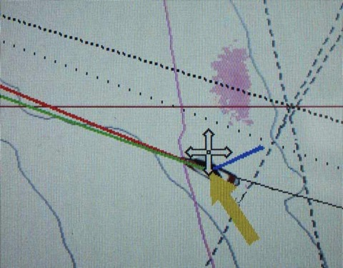
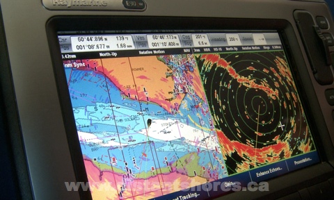
Morning reveals a grey sky, a high grey dome of clouds with isolated heavier clouds and showers marching out of the east. Perhaps we won't have our normal trade-winds today. I flip on the radar to take a look at the approaching weather. I normally use the chart mode to see showers with the radar overlaid on the plotter in purple. Zooming out to see the surrounding islands I put the radar on its 48 mile range and there are the showers, a nice soft purple splotch coming up past St Barths . Over the next few minutes I plot the shower putting waypoints on it's centre until I see its approximate path. Looks like it will skim past us to the north, so I adjust course a bit further south to see if we can avoid it altogether.
What a miracle that we can have this technology of Radar on our boats! Radar is a system that uses transmitted radio waves to determine the range and direction of objects. Radar (from RAdio Detection And Ranging) sprung from 1900's technology and came into effective use in World War II, where it was influential in the outcome of some major battles. German aircraft were detected approaching for the Battle of Britain in 1940, and at sea the first ships with Radar had a huge advantage against those without. Imagine opposing fleets on a dark mediterranean night, one with radar picking out the opposition, and the other essentially blind!
Today's modern radars benefit from dramatic improvements on this technology. Our current unit (an 18 inch Raymarine 418HD radome) uses a miserly 60 watts. A detailed image of reflected targets up to 48 miles away but using just the power of a 60 watt lightbulb! By concentrating that power into short bursts we can shine a 4000 watt pulse and catch the reflection as far away at 48 miles!
Reduced visibility and working in the dark is another big advantage of Radar. With flukey winds we have a slow passage from St Martin 80 nm across the Anegada Passage and our planned arrival in Virgin Gorda in the British Virgin Islands slips to 9 o'clock. We know the channel having done it several times, most recently just a few months earlier, otherwise we wouldn't attempt a night approach. But even with local knowledge and the weather clearing as we near Virgin Gorda it is very nice to have the radar on again, picking up small craft, and confirming the chart as you can see the island overlaid nicely in purple.
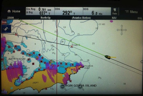
Note also the target showing as a purple dot on the top right of the screen above. The radar shows this boat is nearly a mile north of us, so we can keep an eye on him even though he is not properly lit and would otherwise be a bit of a worry. Another nice use of the radar!
Here are a few other uses for radar…
Radar is an extremely powerful tool for the cruising sailor.
You Might also like the following...
Tropical Storm Chantal Arrives
Making Money While Cruising
Maintaining a Homebase
About the Southerly 49
Top 10 Canal Journeys
We are up in the dark and raising anchor before dawn. It is a Caribbean morning with a salt tang blowing a flukey breeze off the beach and St Martin's distinctive lagoon behind. The high bulk of the island to the east hides the orange glow of sunrise and shades us from the trade-winds. Five large cruise ships are approaching from the southwest, steaming past us toward Philipsburg. It will be busy in St Martin today. But I am looking forward to a day at sea after our time in this bustling island.
Morning reveals a grey sky, a high grey dome of clouds with isolated heavier clouds and showers marching out of the east. Perhaps we won't have our normal trade-winds today. I flip on the radar to take a look at the approaching weather. I normally use the chart mode to see showers with the radar overlaid on the plotter in purple. Zooming out to see the surrounding islands I put the radar on its 48 mile range and there are the showers, a nice soft purple splotch coming up past St Barths . Over the next few minutes I plot the shower putting waypoints on it's centre until I see its approximate path. Looks like it will skim past us to the north, so I adjust course a bit further south to see if we can avoid it altogether.
What a miracle that we can have this technology of Radar on our boats! Radar is a system that uses transmitted radio waves to determine the range and direction of objects. Radar (from RAdio Detection And Ranging) sprung from 1900's technology and came into effective use in World War II, where it was influential in the outcome of some major battles. German aircraft were detected approaching for the Battle of Britain in 1940, and at sea the first ships with Radar had a huge advantage against those without. Imagine opposing fleets on a dark mediterranean night, one with radar picking out the opposition, and the other essentially blind!
Today's modern radars benefit from dramatic improvements on this technology. Our current unit (an 18 inch Raymarine 418HD radome) uses a miserly 60 watts. A detailed image of reflected targets up to 48 miles away but using just the power of a 60 watt lightbulb! By concentrating that power into short bursts we can shine a 4000 watt pulse and catch the reflection as far away at 48 miles!
Reduced visibility and working in the dark is another big advantage of Radar. With flukey winds we have a slow passage from St Martin 80 nm across the Anegada Passage and our planned arrival in Virgin Gorda in the British Virgin Islands slips to 9 o'clock. We know the channel having done it several times, most recently just a few months earlier, otherwise we wouldn't attempt a night approach. But even with local knowledge and the weather clearing as we near Virgin Gorda it is very nice to have the radar on again, picking up small craft, and confirming the chart as you can see the island overlaid nicely in purple.
Note also the target showing as a purple dot on the top right of the screen above. The radar shows this boat is nearly a mile north of us, so we can keep an eye on him even though he is not properly lit and would otherwise be a bit of a worry. Another nice use of the radar!
Here are a few other uses for radar…
- Foggy conditions - extremely good in this situation it is a huge stress-reliever.
- Picking up buoys on approach in the dark or fog (set the radar to close range for this (our Raymarine radar has a "buoy mode" with tuning set for this)
- Confirming chart data for new areas we haven't visited - you can see the chart lines up with the "real world" as shown by the radar.
- Confirming AIS targets as the two will overlay revealing other non-AIS targets
Radar is an extremely powerful tool for the cruising sailor.
You Might also like the following...
Tropical Storm Chantal Arrives
Making Money While Cruising
Maintaining a Homebase
About the Southerly 49
Top 10 Canal Journeys
Fogbound! Crossing the Channel
04/10/11 03:35
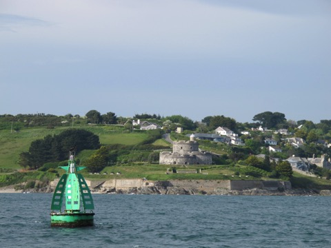
The passage began with a beautiful afternoon departure. Passing the castle guarding the entrance to Falmouth harbour we pointed the bows towards France. There was a light southerly breeze and a forecast for a quiet night.
The channel crossing is around 100 miles from Falmouth to the Rade de Brest and we needed to reach the strong tides of the Chenal du Four (at the corner of France near Brest) near dawn when they would be in our favour. This means crossing one of the busiest shipping lanes in the world in the dark. Then the fog rolled in!
I don’t think we have ever seen a thicker fog! We could just see the bow of the boat 40 feet away, but nothing more. Our navigation lights created pools of light in the fog and mist settled on everything. For the next 8 hours we could see nothing past our own decks.
AIS
I have written before about AIS and how much we like having it. WELL!! If ever a device paid its keep it was that night. We could see every ship out there and they could see us as well. We did not have to worry about the shipping lanes.
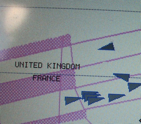
We were crossing before the start of the TSS (Traffic Separation Scheme) which directs shipping around the corner of France so were not obligated to cross at a direct right angle. However our course was at right angles anyway. And when shipping is so nice and organized it is best to cross it quickly and be away from the area as soon as possible.
RADAR
Of course not all boats have an AIS transponder. So our biggest worry in the thick fog is smaller boats such as fishing boats and other yachts. As we were leaving the coast there was another sailboat in sight and he DID have an AIS. But naturally there might be others. We have used the radar often in broad daylight to check how it works at picking up smaller boats. It is good to practice with the equipment. I find that we usually see a reasonable echo for small sailboats around 3 miles away. Over here in Europe most boats have a radar reflector mounted up on the mast - the most popular by far is the ones that look like a white 6 inch diameter fender. But even when I can’t see a reflector in their rigging, we usually pick up sailboats 3 miles away. Certainly 1-2 miles even small day-boats show up as a nice target. Sheryl is particularly good at reading the radar, noticing a faint target that only appears occasionally will then reappear in the same spot after a couple more rotations of the scanner.
The fog lay like a heavy wool blanket over the sea. There was no moon but during Sheryl’s watch from 2200 to 0100 the fog would occasionally clear above the mast head to reveal a few stars. But still at deck level we were rolling along in a thick air, cut into precise sector slices by our nav lights. We were not yet in the shipping lanes so there were no ships during this watch. Sheryl saw two targets on radar, one crossing our bow at two miles distance. With worrying radar targets, we set a few waypoints on it’s position to mark their track. One of the targets must have been a fishing boat nearly stationary as the waypoints showed it almost still.
There were also a number of larger fishing boats, thankfully all running AIS. In one case, I was just altering course to avoid it when it turned directly towards us just 2 miles away.
"Distant Shores Distant Shores, This is fishing vessel Eruva. We are fishing and are just about to alter course and I will be travelling at 045 degrees. Could you give me four cables searoom astern."
"Eruva, Distant Shores, roger we will alter course to pass your stern by half a mile"
What a great recommendation for the AIS technology. In fog we both could see each other clearly, and he knew our boat name to give us a call.
The fog cleared by dawn and we arrived in France at Camaret!
AIS Transponders by Raymarine
Radar in Hi-Def and Digital
10/04/10 07:38
Leaving Portsmouth Harbour onboard Raymarine’s test boat.
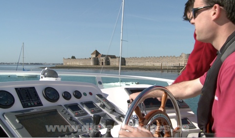
Yesterday we got a chance to go out on Raymarine’s amazing test and product development boat in Portsmouth Harbour on the Solent. The “Raymariner” is a 42 foot Hardy made here in the UK and it must have more electronics aboard than any other boat less than a hundred feet. I counted six radar arrays, 8 wind indicators and 14 GPS receivers on deck.
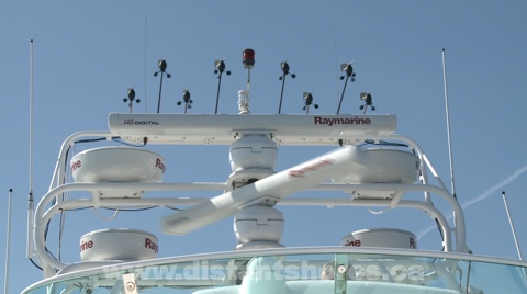
The boat has 7 (seven!!) complete autopilot systems! Yesterday was one of the first sunny spring days here. We were out for about 3 hours and got a chance to see the new HD radar technology in action. The area that would normally be the saloon on this boat has been purpose-built as a testing lab with desks that can patch into any of the sensors or systems. Using one of the new E-Wide series of Raymarine plotters (hybrid touch screens) we were able to compare various radar scanners operating in a real envirionment at sea. First we saw a large “open array” scanner, of course with excellent definition. I don’t have enough experience with the larger radars to compare but the images of the surrounding marks and coastline were very good. Stunning really!
But now they have HD Digital Radar. What does this really mean?
Lets take Digital Radar first. Traditional radar scanners have had very little of the working circuitry up in the radar itself. A huge thick cable runs from the display set up to the radome. But with digital radar, most of the functionality is moved up to the scanner. This has a number of advantages. The cable is much smaller saving quite a lot of weight aloft. It can talk to any display you have. We have 2 screens in the cockpit and previously that would mean the radar would have been run from one of them. So you would always need that on switched on to have radar. Now either display can run the radar. And I understand that digital radar makes a better image since the signal is interpreted right up in the scanner as it is received rather than travelling down the long wires to the display. Less signal loss.
HD - High Definition Radar - This sounds like just a buzz-word - can radar be “hi-def”? Well radar is really about definition. Defining a target by bouncing a signal pulse off it. Varying the pulse length and power allow you to get better definition, and measuring how strongly the signal comes back as well as how long it took to return (which means how far away it is)
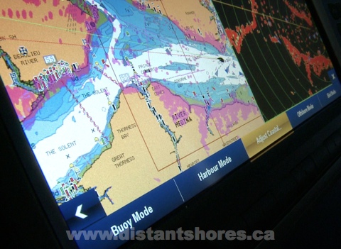
With HD Radar the power of the modern computer is put to use tweaking the outgoing signal, and analyzing the returned pulse. Interpreting and analyzing means the radar can display an image that allows us to recognize the features we are interested in. The unit will tune itself and reduce sea clutter - even adapting to the different conditions. Below the menu shows easy setup to match conditions - “Buoy Mode, Harbour Mode, Offshore Mode and even “Bird Mode” to detect flocks of birds that might indicate good fishing!
We have had 2 previous Raymarine radars, both 18 inch radomes. I was interested to see how the smaller radome would benefit from the HD Digital technology. I asked to see an image with the smaller radome as that is what most sailboats use - fitting either an 18 or 24 inch scanner in a dome to avoid tangling rigging in a spinning open array scanner. The image looked very detailed and clear to me! One of the big improvements seemed to be the reduced amount of clutter and less tuning needed. The automatic modes combined with overlaying the image on the chart makes an image that is easily recognizable to someone who isn’t a radar expert. As most of us sail short-handed (without a dedicated navigator on board) then having an easy to use radar is a great asset.
Radar is still one of the best upgrades you can do to increase safety and reduce stress especially at night and in reduced visibility. Here are my radar hints...
Yesterday we got a chance to go out on Raymarine’s amazing test and product development boat in Portsmouth Harbour on the Solent. The “Raymariner” is a 42 foot Hardy made here in the UK and it must have more electronics aboard than any other boat less than a hundred feet. I counted six radar arrays, 8 wind indicators and 14 GPS receivers on deck.
The boat has 7 (seven!!) complete autopilot systems! Yesterday was one of the first sunny spring days here. We were out for about 3 hours and got a chance to see the new HD radar technology in action. The area that would normally be the saloon on this boat has been purpose-built as a testing lab with desks that can patch into any of the sensors or systems. Using one of the new E-Wide series of Raymarine plotters (hybrid touch screens) we were able to compare various radar scanners operating in a real envirionment at sea. First we saw a large “open array” scanner, of course with excellent definition. I don’t have enough experience with the larger radars to compare but the images of the surrounding marks and coastline were very good. Stunning really!
But now they have HD Digital Radar. What does this really mean?
Lets take Digital Radar first. Traditional radar scanners have had very little of the working circuitry up in the radar itself. A huge thick cable runs from the display set up to the radome. But with digital radar, most of the functionality is moved up to the scanner. This has a number of advantages. The cable is much smaller saving quite a lot of weight aloft. It can talk to any display you have. We have 2 screens in the cockpit and previously that would mean the radar would have been run from one of them. So you would always need that on switched on to have radar. Now either display can run the radar. And I understand that digital radar makes a better image since the signal is interpreted right up in the scanner as it is received rather than travelling down the long wires to the display. Less signal loss.
HD - High Definition Radar - This sounds like just a buzz-word - can radar be “hi-def”? Well radar is really about definition. Defining a target by bouncing a signal pulse off it. Varying the pulse length and power allow you to get better definition, and measuring how strongly the signal comes back as well as how long it took to return (which means how far away it is)
With HD Radar the power of the modern computer is put to use tweaking the outgoing signal, and analyzing the returned pulse. Interpreting and analyzing means the radar can display an image that allows us to recognize the features we are interested in. The unit will tune itself and reduce sea clutter - even adapting to the different conditions. Below the menu shows easy setup to match conditions - “Buoy Mode, Harbour Mode, Offshore Mode and even “Bird Mode” to detect flocks of birds that might indicate good fishing!
We have had 2 previous Raymarine radars, both 18 inch radomes. I was interested to see how the smaller radome would benefit from the HD Digital technology. I asked to see an image with the smaller radome as that is what most sailboats use - fitting either an 18 or 24 inch scanner in a dome to avoid tangling rigging in a spinning open array scanner. The image looked very detailed and clear to me! One of the big improvements seemed to be the reduced amount of clutter and less tuning needed. The automatic modes combined with overlaying the image on the chart makes an image that is easily recognizable to someone who isn’t a radar expert. As most of us sail short-handed (without a dedicated navigator on board) then having an easy to use radar is a great asset.
Radar is still one of the best upgrades you can do to increase safety and reduce stress especially at night and in reduced visibility. Here are my radar hints...
- Display should be mounted so it is visible from the helm so the skipper can make quick decisions
- Practice with it on nice days when you can see what you are doing and compare real world to the radar display
- Make sure the unit can be dimmed down enough to be used at night without ruining your night vision. Raymarine does this nicely and also has a night palette changing to darker colours.Try out the overlay mode where the radar image is synchorized and drawn on top of the chart (as above left) This is my favourite mode.
- Get the first mate involved as well. Anyone nervous of sailing at night can find reassurance in “seeing” whats around with radar
- Add the AIS display on the radar overlay as well. Then ships show up nicely on the image too.