Weather4D Passage Routing Review - Updated
12/12/14 07:46 Filed in: Offshore sailing | Planning
By Paul Shard, Copyright 2015. All rights reserved.
Scroll Down to see update following the passage
Do you wonder about the best way to plan a passage? Ask yourself questions such as “Can I make a passage before the next front comes in? How long will it take? When is the best time to tack, assuming the weather will be coming more from the east in the next few days?”
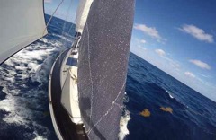
These are questions Sheryl and I have been asking ourselves since we are planning a big jump directly from the Exumas in the Bahamas down to Saint Martin in the Caribbean this week. It’s usually a tough upwind slog so planning the best day to leave might make all the difference between a tough bash to windward and an enjoyable passage. If we can catch a window where a front is approaching, we will grab the winds that go to the northwest and north which might allow us to make the necessary easting until we turn right and pick up the tradewinds from the east down to the Caribbean. This is the traditional strategy for this passage.
I have always done this planning using a manual method. I look at GRIB files and step through the passage – updating our course and guessing how many miles we will make in the next day. If the wind is on the beam we might make 7-8 knots – perhaps 175 miles in 24 hours. By then the forecast might predict winds a bit more on the nose so we will be slowing a bit.... hmmm. So perhaps if we leave a little earlier and motor a bit the first day we might pick up the winds so we get away from the weather...
Does this sound familiar? Or does the whole routing thing sound too complicated? What to do??
Weather4D Routing Software
How about an app that does the weather routing scenarios for you? Plus figures out alternative options for your course. Just plug in a start date, define the weather area you want to load for the GRIB file and Voila! (that’s French for “there you are!”)
I have been testing out an app called “Weather4D” and related app “iPolar” on my iPhone. A bit complicated at first but quite a revelation in route-planning. Let’s jump in!
Weather data can be displayed on many websites and using GRIB viewers so you can watch the weather animate through time over your upcoming route. But in these cases you still have to do the actual route planning. You will need to plot a proposed course and plot waypoints based on how far you think you might sail each day.
More Than just a Grib Viewer
Weather4D is not just a grib viewer – but so much more. It will do routing – advancing you along your planned course so you can visualize the weather as you will be making your passage. But how can it do that? How will the app know how fast we will be going?? For that you need the info on how fast you can sail on each heading relative to the wind. This is often represented by a “polar” predicted performance diagram.
Polar Performance Data
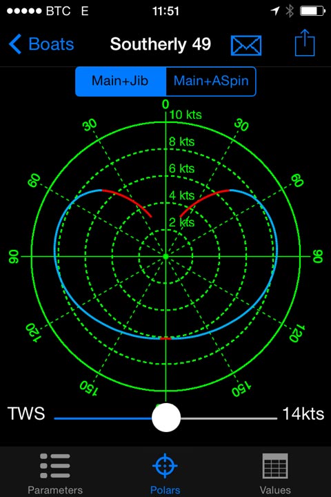
You can import Polar performance information for your own sailboat into the Weather4D app. I used the companion product called iPolar to generate a predicted polar sailing table by inputing LOA, LWL, beam, displacement and our Southerly 49 sail areas. Here is a capture screen of the diagram (showing the 14 knot performance set by the slider underneath). It appears to be fairly close to the polar diagram Southerly published for the 49. Good enough anyway to give a reasonable input for the program.
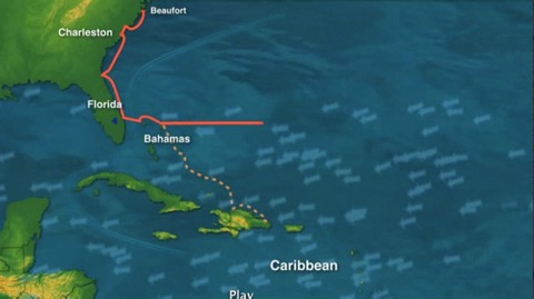
Before I get into much more complicated descriptions – here is a nice graphic to show why its all worth it. Weather4D has calculated how much we will be sailing along our planned route (red boat), and even generated a better suggest route (green boat).
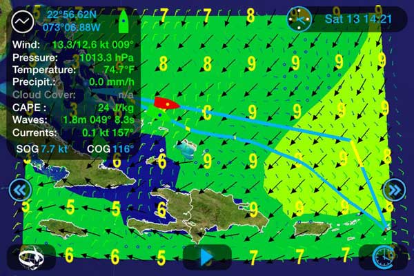
This is a scenario of our upcoming trip from the Exumas (upper left) to Saint Martin (lower right). We have just started and you can see our boat in red following along the route I input. Using the polar performance data we put in, Weather4D is applying the GRIB file data and sailing us along my course.
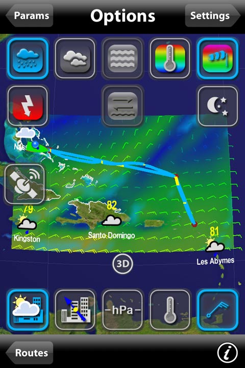
Wind and wave data is displayed on the panel – and I have set the screen to display the waves as background shading. Winds are the small arrows, waves are the black arrows.
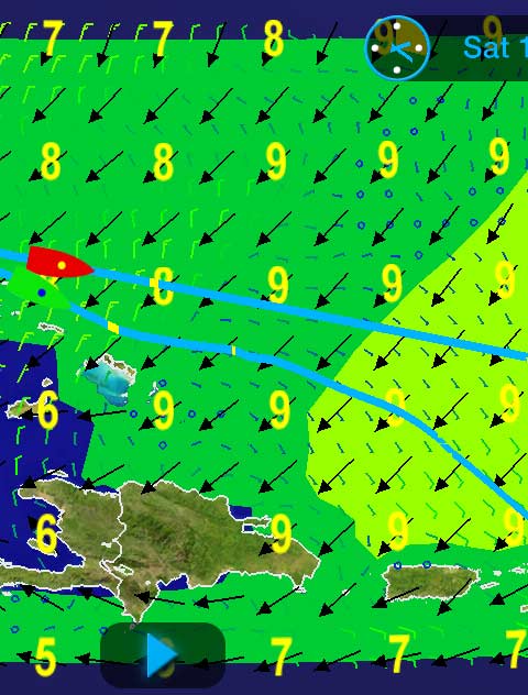
However, notice the second route, also in blue but below my planned course. The green boat is the routing simulated alternative. This route is the optimum course calculated by Weather4D. Note below how (if all goes according to forecast :-) we might arrive earlier by the route the Weather4D routing algorithm is suggesting. The green boat is coming in more than 6-8 hours earlier!
The two routes compared: If we follow my route we will have a slow section (in yellow on the right side of the screen) where the winds are too light to make a good speed. Note the suggested lower route has much less yellow section.
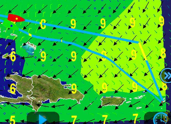
Weather routing is tough work and very “CPU-Intensive”. It takes a minute or so to calculate our best potential route. This is on an iPhone 4 so newer phones would be faster - I would recommend using this on a new iPad - Christmas is coming :-)
Here I snapped a screen-shot of the process... potential routes are being evaluated as time advances. You can see the far northern options aren't getting us so far as the southern options so it is concentrating more on them.
This will be an ongoing review and I will update it when we arrive in the Caribbean with our thoughts after the passage.
Weather Routing Software - Competition
Predictwind is $199/year and MaxSea has a weather routing module you can add in for $260. Although it might well not do all these packages can, Weather4D at $33 (plus 10.99 if you want iPolar) seems to be a useful package to run on your tablet or smartphone. We will report back on the passage experience when we arrive in Saint Martin in a week or so.
Has anyone got experience with Weather4D or the competing Predictwind Service or MaxSea? Please chime in with comments!
Update Dec 21/14 - Choosing the Route
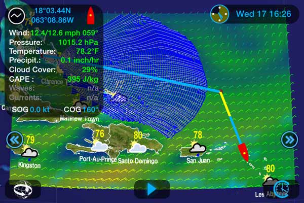
Greetings from St. Martin! What an amazing passage we just had sailing from the Bahamas! Looking at the suggested route above I decided to modify our route a bit south and plan one that would take us more directly to St Martin... see below for the plotter track we did on our Raymarine chartplotter which uses Navionics charts. This is our actual track in black, with red dots for log points, noon fixes etc.
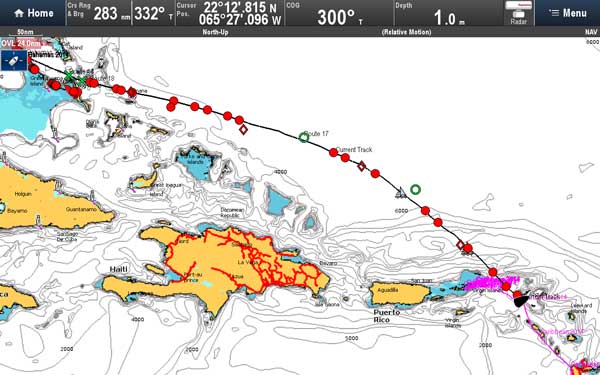
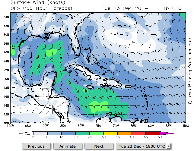
I know that winds in this area rarely come from the south so I wanted to stay further north in case our predicted N-NE winds didn’t last as long as the forecast said (which was that they were to swing more NE-ENE at the end of our passage). Here is a typical weather pattern for this time of year - lots of easterly winds - no chance of making the jump we just did.
Grab Your Weather Window
So how do you plan a successful passage? There are so many amazing tools we can use nowadays that it is much easier than it used to be to help plan a reasonable route for your boat and your crew. I will definitely be adding the regular use of the Weather4D tool to my passage planning routine from now on.
- Check general weather patterns if you aren’t familiar with the area... See Pilot Charts, cruising guides and general routing ideas such as Jimmy Cornell’s World Cruising Routes.
- Check the current situation with sites such as Passageweather
- Roughly evaluate your proposed route to see if you will have acceptable weather scenarios for your trip by drawing it out on a chart advancing your position by typical day’s run (judging from the forecast winds and seas)
- Simulate your route using Weather4D.
- Set Sail!
Thoughts on Weather Routing
Success of the weather routing will depend on 2 major factors...
The accuracy of weather forecasts - obviously less accurate the further out the forecast is. Your own boat and crew’s ability to meet your predicted performance.
Weather Forecast Accuracy
In our case the forecast we received turned out to be quite accurate right up to our arrival as the winds had shifted to NE-ENE by the 5th day. 12 hours into the passage we passed Rum Cay in the Bahamas and our Cellphone data link got a weather update but after that we had no more data connection. This meant we could not receive an updated grib file for Weather4D while we were underway but we did receive audio forecasts on our SSB radio.
Polar Diagram and Predicted Performance
Did we meet our predicted speeds? Well, mostly :-)
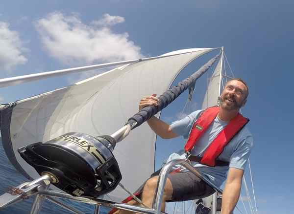
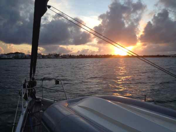
We regularly make 7.5-8 knots sailing on a beam reach and with steady winds we made progress as predicted. But the perfect world of Polar predicted performance doesn’t take into account normal wind fluctuations and a short-handed crew. With just the two of us on board there were a few occasions where we wouldn’t sail at our peak. For example, we will not use our big genoa with winds over 20 knots, so if it's evening and there are occasional gusts over 20 we will furl our genoa and put out our smaller self-tacking jib. This is a tough little 100% jib and it is quite capable of handling winds well above 20 knots so we can have a more relaxed time on our night watches. But this means we are sailing at 6 knots or so as the wind might be just 13-14 kts. If we had a racing crew we would be changing sails and keeping much closer to our “predicted performance”. I think if we had done this we would have come closer to the predicted arrival time. In the end we arrived at 5 o’clock in the afternoon - about 8 hours after Weather4D suggested we would get in. Still in time to celebrate a sunset in the lagoon at Saint Martin and have a nice night’s sleep.
Travel the world with us aboard Distant Shores
Order the Super Pack on DVD and get Season 1-10 Downloadable.
Order the Super Pack on Vimeo and we will send you the code for Season 10 as a bonus.
J&K Via Facebook“It’s because of your first season that we took off to go sailing and meet new people. 45k miles later, we're more indebted to you than ever. Thank you!”
blog comments powered by Disqus