Fogbound! Crossing the Channel
04/10/11 02:35
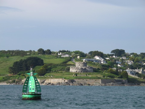
The passage began with a beautiful afternoon departure. Passing the castle guarding the entrance to Falmouth harbour we pointed the bows towards France. There was a light southerly breeze and a forecast for a quiet night.
The channel crossing is around 100 miles from Falmouth to the Rade de Brest and we needed to reach the strong tides of the Chenal du Four (at the corner of France near Brest) near dawn when they would be in our favour. This means crossing one of the busiest shipping lanes in the world in the dark. Then the fog rolled in!
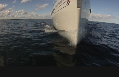
I don’t think we have ever seen a thicker fog! We could just see the bow of the boat 40 feet away, but nothing more. Our navigation lights created pools of light in the fog and mist settled on everything. For the next 8 hours we could see nothing past our own decks.
AIS
I have written before about AIS and how much we like having it. WELL!! If ever a device paid its keep it was that night. We could see every ship out there and they could see us as well. We did not have to worry about the shipping lanes.
We were crossing before the start of the TSS (Traffic Separation Scheme) which directs shipping around the corner of France so were not obligated to cross at a direct right angle. However our course was at right angles anyway. And when shipping is so nice and organized it is best to cross it quickly and be away from the area as soon as possible.
RADAR
Of course not all boats have an AIS transponder. So our biggest worry in the thick fog is smaller boats such as fishing boats and other yachts. As we were leaving the coast there was another sailboat in sight and he DID have an AIS. But naturally there might be others. We have used the radar often in broad daylight to check how it works at picking up smaller boats. It is good to practice with the equipment. I find that we usually see a reasonable echo for small sailboats around 3 miles away. Over here in Europe most boats have a radar reflector mounted up on the mast - the most popular by far is the ones that look like a white 6 inch diameter fender. But even when I can’t see a reflector in their rigging, we usually pick up sailboats 3 miles away. Certainly 1-2 miles even small day-boats show up as a nice target. Sheryl is particularly good at reading the radar, noticing a faint target that only appears occasionally will then reappear in the same spot after a couple more rotations of the scanner.
The fog lay like a heavy wool blanket over the sea. There was no moon but during Sheryl’s watch from 2200 to 0100 the fog would occasionally clear above the mast head to reveal a few stars. But still at deck level we were rolling along in a thick air, cut into precise sector slices by our nav lights. We were not yet in the shipping lanes so there were no ships during this watch. Sheryl saw two targets on radar, one crossing our bow at two miles distance. With worrying radar targets, we set a few waypoints on it’s position to mark their track. One of the targets must have been a fishing boat nearly stationary as the waypoints showed it almost still.
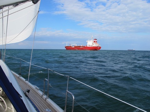
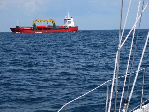
There were also a number of larger fishing boats, thankfully all running AIS. In one case, I was just altering course to avoid it when it turned directly towards us just 2 miles away.
"Distant Shores Distant Shores, This is fishing vessel Eruva. We are fishing and are just about to alter course and I will be travelling at 045 degrees. Could you give me four cables searoom astern."
"Eruva, Distant Shores, roger we will alter course to pass your stern by half a mile"
What a great recommendation for the AIS technology. In fog we both could see each other clearly, and he knew our boat name to give us a call.
The fog cleared by dawn and we arrived in France at Camaret!
AIS Transponders by Raymarine
Comments
Dealing with Shipping - AIS Part 2
29/06/10 02:24
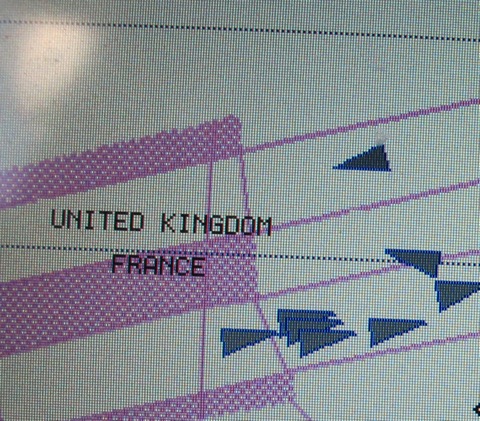
3 years ago when we first got an AIS receiver we were SO happy that we could easily see and understand ships. The AIS receiver allowed us to see all ships within a 15-35 mile range AND to know their name and call sign so we could call them if we saw they would come close to us. Here is a typical view of the plotter showing ships as small triangles.
We are in the upper left corner with the yellow arrow indicating the wind, blue is line showing a small current/leeway.
The greyed lines are showing the shipping traffic separation scheme near France. With the AIS you can see the exact position of the shipping and instantly understand what they are doing. For instance, the ship in the top center of the screen appears to be heading for us. But he is obviously in the lanes so we know he will turn shortly and will not be a concern. And If he was we could just look at him for more information. AIS shows all kind of info including length, speed, name callsign etc. Here is a sample screen.
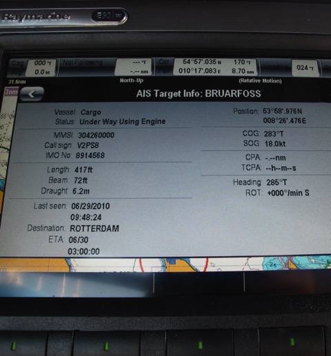
Note we even see the ship’s length, beam and draft. The CPA is “Closest point of Approach” and the TCPA is the time until we will reach that close point. In this case the ship is heading away from us so there are no number for CPA and TCPA.
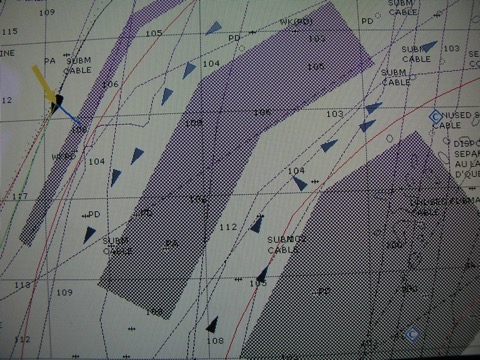
Keeping an eye on approaching ships as we cross the english channel to Guernsey in the Channel Islands.
Should we alter course? Is there a risk here? No, this ship is anchored and we knew this miles in advance since the AIS showed their speed as 0.1 knot and the status as anchored!
AIS Class B for smaller boats
So what could be better than having an AIS receiver??
How about an AIS transmitter like the big ships have! That way ships can see us as well. They will get automatic alarms if we are going to come close to them. Although they should see us on their radar, this is a much more secure system and works without needing an operator. In conditions of reduced visibility they will know exactly where we are as well as our speed, name and callsign. This is called AIS Class B.
With Distant Shores II we have added one of the new Raymarine AIS transmitters. The newly designed AIS Class B Raymarine AIS500.
This is a very cleverly designed system and integrates amazingly into the Raymarine network. It uses the ships existing VHF antenna so it doesn’t need almost any additional wiring. And since it displays the shipping on the plotter it doesn’t need a separate monitor either. The AIS500 is just a small box that is hidden away, using very little power.
Now that we have had a couple of passages with the system I can report back that it is fantastic!! Crossing the English Channel to the Channel Islands I took this screenshot as we were crossing the shipping lanes near Guernsey. Busy! Similar as we were crossing the North Sea up to the Netherlands.
Now the ships see us as a target on their systems and are instantly alerted if we will come close. In practice we have found them to be happily swerving a bit to avoid us without us needing to call them in advance. Of course we also change course to avoid the ships, but now we are broadcasting AIS they will immediately see we have altered course and realize they don’t need to.
I cannot stress enough how the AIS system has reduced our worries on sea passages. Especially at night it can be difficult to deal with shipping. In the event there are many ships it used to be almost impossible to call the ship you were worried about since you didn’t know their name. Now with AIS you call the exact ship you are concerned about. And now our with AIS Class B transmitter they will know who it is so they could call us as well. Since AIS uses very little power and is not very expensive it seems like a very intelligent purchase for sailors who venture out to sea as we do. It is the best kind of insurance - the kind that reduces the risk of a problem in the first place!
We are in the upper left corner with the yellow arrow indicating the wind, blue is line showing a small current/leeway.
The greyed lines are showing the shipping traffic separation scheme near France. With the AIS you can see the exact position of the shipping and instantly understand what they are doing. For instance, the ship in the top center of the screen appears to be heading for us. But he is obviously in the lanes so we know he will turn shortly and will not be a concern. And If he was we could just look at him for more information. AIS shows all kind of info including length, speed, name callsign etc. Here is a sample screen.
Note we even see the ship’s length, beam and draft. The CPA is “Closest point of Approach” and the TCPA is the time until we will reach that close point. In this case the ship is heading away from us so there are no number for CPA and TCPA.
Keeping an eye on approaching ships as we cross the english channel to Guernsey in the Channel Islands.
Should we alter course? Is there a risk here? No, this ship is anchored and we knew this miles in advance since the AIS showed their speed as 0.1 knot and the status as anchored!
AIS Class B for smaller boats
So what could be better than having an AIS receiver??
How about an AIS transmitter like the big ships have! That way ships can see us as well. They will get automatic alarms if we are going to come close to them. Although they should see us on their radar, this is a much more secure system and works without needing an operator. In conditions of reduced visibility they will know exactly where we are as well as our speed, name and callsign. This is called AIS Class B.
With Distant Shores II we have added one of the new Raymarine AIS transmitters. The newly designed AIS Class B Raymarine AIS500.
This is a very cleverly designed system and integrates amazingly into the Raymarine network. It uses the ships existing VHF antenna so it doesn’t need almost any additional wiring. And since it displays the shipping on the plotter it doesn’t need a separate monitor either. The AIS500 is just a small box that is hidden away, using very little power.
Now that we have had a couple of passages with the system I can report back that it is fantastic!! Crossing the English Channel to the Channel Islands I took this screenshot as we were crossing the shipping lanes near Guernsey. Busy! Similar as we were crossing the North Sea up to the Netherlands.
Now the ships see us as a target on their systems and are instantly alerted if we will come close. In practice we have found them to be happily swerving a bit to avoid us without us needing to call them in advance. Of course we also change course to avoid the ships, but now we are broadcasting AIS they will immediately see we have altered course and realize they don’t need to.
I cannot stress enough how the AIS system has reduced our worries on sea passages. Especially at night it can be difficult to deal with shipping. In the event there are many ships it used to be almost impossible to call the ship you were worried about since you didn’t know their name. Now with AIS you call the exact ship you are concerned about. And now our with AIS Class B transmitter they will know who it is so they could call us as well. Since AIS uses very little power and is not very expensive it seems like a very intelligent purchase for sailors who venture out to sea as we do. It is the best kind of insurance - the kind that reduces the risk of a problem in the first place!
Dealing with Shipping
28/05/10 02:26
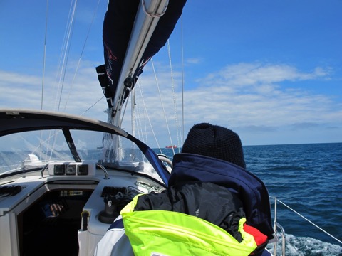
Crossing the English Channel means crossing one of the busiest area of shipping in the world, and there is also the possibility of fog or reduced visibility to make it more thrilling! Just what you need when facing 4-5 ships heading your way all at once... Shipping used to be a real worry and night passages were filled with bearings and calculations and worry as we observed their lights on the horizon and tried to figure out their intentions.
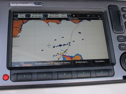
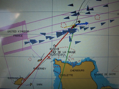
AIS to the rescue! This crossing was another good example of why an AIS unit is an excellent investment for anyone venturing out into busy waters. We left the dock in Chichester at 0100 and by 0130 had cleared the mouth of the harbour into the English Channel. Our plotter on deck showed our position as well as the fact that we had more-or-less got the expected current. It also showed all the ships in a good 20 mile radius since the AIS receiver passes that info on to the Raymarine plotters.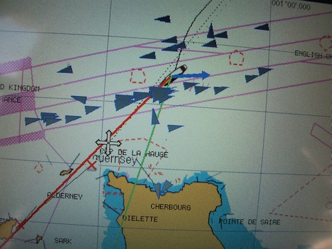
We shot this image a bit later as we were closer to France. The blue arrow on our boat indicates the current, the red line our heading and the green line where we are actually going with the effect of the current. You can see there are quite a few ships just ahead as we approach the east-bound shipping. When we zoom in we see most of the ships will pass easily ahead or behind us since the AIS also calculates the “closest point of approach” and the time until that point for each ship. Best of all we know the names of the ships so we can call them if we think there is a problem! In this case none were close enough to warrant a call. The stress reduction from having a plotter on deck with AIS info on it is truly amazing!
Now for the first time we have an AIS transponder meaning we are also transmitting so the ships can also see us on their display. Even better!
We arrived in Guernsey in the early afternoon after a calm and stress free crossing. Then on to Jersey where we saw the highest tides we have ever seen!! We arrived just after low water and waited outside the marina.
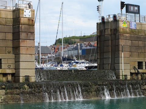
We are looking at the only entrance to the marina. This wall is the “sill” and is almost 3 meters high blocking our way in. When the tide rises it will cover the sill and allow us in. It will actually cover the sill by more than 5 meters! The tide this day was 10 meters - over 30 feet!!
I took this from the quayside - basically what will be water level when the tide is up. It is quite amazing sailing in these waters since the whole landscape changes so much with the dramatic rise and fall of the tides.
AIS to the rescue! This crossing was another good example of why an AIS unit is an excellent investment for anyone venturing out into busy waters. We left the dock in Chichester at 0100 and by 0130 had cleared the mouth of the harbour into the English Channel. Our plotter on deck showed our position as well as the fact that we had more-or-less got the expected current. It also showed all the ships in a good 20 mile radius since the AIS receiver passes that info on to the Raymarine plotters.
We shot this image a bit later as we were closer to France. The blue arrow on our boat indicates the current, the red line our heading and the green line where we are actually going with the effect of the current. You can see there are quite a few ships just ahead as we approach the east-bound shipping. When we zoom in we see most of the ships will pass easily ahead or behind us since the AIS also calculates the “closest point of approach” and the time until that point for each ship. Best of all we know the names of the ships so we can call them if we think there is a problem! In this case none were close enough to warrant a call. The stress reduction from having a plotter on deck with AIS info on it is truly amazing!
Now for the first time we have an AIS transponder meaning we are also transmitting so the ships can also see us on their display. Even better!
We arrived in Guernsey in the early afternoon after a calm and stress free crossing. Then on to Jersey where we saw the highest tides we have ever seen!! We arrived just after low water and waited outside the marina.
We are looking at the only entrance to the marina. This wall is the “sill” and is almost 3 meters high blocking our way in. When the tide rises it will cover the sill and allow us in. It will actually cover the sill by more than 5 meters! The tide this day was 10 meters - over 30 feet!!
I took this from the quayside - basically what will be water level when the tide is up. It is quite amazing sailing in these waters since the whole landscape changes so much with the dramatic rise and fall of the tides.